Every year, I return home to Slovakia to visit my family and friends, and the High Tatras are always a part of my plans. These mountains offer more than just breathtaking views—they provide the perfect place to clear my head and reconnect with nature. For several years, I’ve wanted to take on Orla Perć, but something always seemed to get in the way.
This year, I finally made it, sharing the experience with a good friend. In preparation, I trained for three weeks, walking daily distances between 10 to 20 kilometers. This proved essential given the hike’s level of difficulty and physical demands.
Here’s my description of the hike, along with important details for anyone considering taking on this trail.
A Word of Caution:
Orla Perć is not for the faint-hearted. The trail is extremely difficult, primarily due to elevation gain and the extended length of the hike. It’s critical to emphasize that this route is only recommended for highly experienced mountain hikers. Proper preparation, physical conditioning, and an understanding of the risks involved are essential. The exposed sections and unpredictable weather demand both mental and physical fortitude. If you’re planning to attempt Orla Perć, ensure you’re in top physical condition and mentally prepared for what lies ahead.

The Orla Perć section from Zawrat to Krzyżne is a 4.3 km path that runs mostly along the mountain ridge and you will conquer approximately 11 peaks. It begins at Zawrat Pass (2,159 m) and ends at Krzyżne Pass (2,112 m). The route involves an elevation gain of 607 meters and a loss of 651 meters, with the highest point being Kozi Wierch at 2,291 meters. This section typically takes about 6 to 7 hours to complete due to its challenging nature and technical demands.
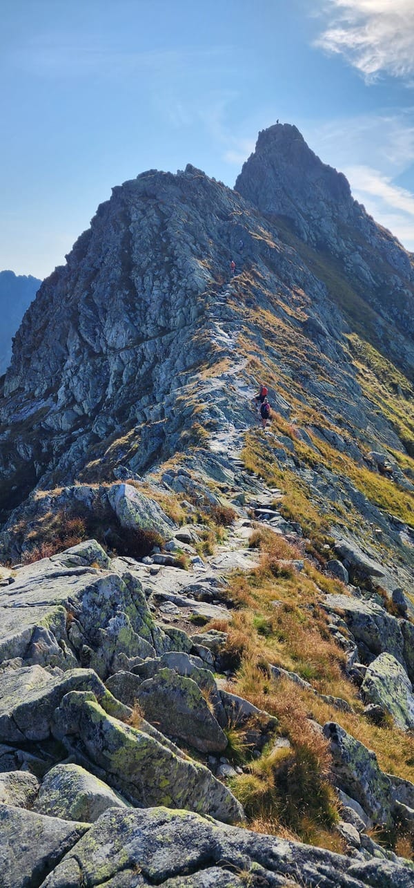
Orla Perć, or Eagle’s Path, is the crown jewel of hiking in the Polish Tatra Mountains and is known for its technical difficulty and stunning vistas. Stretching between Zawrat Pass (2159 m) and Krzyżne Pass (2112 m), this ridge trail offers an exhilarating adventure for experienced hikers. It is equipped with chains, ladders, and pegs to assist climbers, but the path remains perilously exposed at times, making it one of the most difficult and dangerous hikes in Poland and the whole Tatras.
Many of the sections are exposed, offering little protection from falls, and in bad weather, the risk increases dramatically. Despite the chains, ladders, and metal steps, the trail demands a strong head for heights and excellent physical condition. Over 140 fatalities have occurred since its opening, primarily due to falls in exposed areas and bad weather.
What adds to the difficulty is that there are very few exit points along the way, meaning once you begin, you’re often committed to finishing large sections of the hike. The Zawrat to Kozi Wierch section, for example, is one-way only to reduce congestion and risk, meaning you cannot turn back once you start.
What makes Orla Perć especially grueling is the elevation gain and length. There are several ways to approach the Orla Perć hike, with the two most popular starting points being from Lysa Polana or Zakopane. We’ll explore these options in more detail later on.


Overview of the Hike
- Location: High Tatras, Poland
- Difficulty: Very Difficult
- Season: Hiking Season opens around June 15th and closes around October 15th. (can vary slightly each year)
- Best Time: Late June to September for clear trails and stable weather
- Length: Approximately 15 – 30 kilometers, depending on the exact route taken
- Duration: Around 12-17 hours for the full circuit
- Elevation Gain: About 1,400 or 2,200 meters, depending on the exact route taken
- Highest Point: Kozi Wierch 2,291 meters above sea level
- Scenery: The trail frequently follows ridgelines, offering 360-degree views of the valleys below.
- Highlights: The hike includes sections with metal chains and ladders to assist with some of the steepest and most vertical parts of the trail.
Brief History of Orla Perć:
Orla Perć, Poland’s most iconic and dangerous mountain trail, was first envisioned by Polish poet and priest Franz Nowicki in 1901. He proposed a trail that would traverse the ridge of the High Tatras, offering hikers stunning views of the surrounding peaks and valleys. The trail was constructed between 1903 and 1906 with the help of Ksawery Trylski and other volunteers like Walenty Gadowski. Originally intended as a scenic route for mountaineers and pilgrims, Orla Perć quickly gained a reputation for its technical difficulty, exposure and significant risks involved.
Despite these safety features, Orla Perć is not considered a via ferrata. A via ferrata is characterized by continuous steel cables that hikers can clip their safety harnesses to, providing a secure ascent. While Orla Perć does have sections with chains and ladders, these are not continuous, and there are stretches where hikers must rely solely on their own skill and judgment.
There were discussions about converting it into a proper via ferrata, but this idea was ultimately rejected to preserve the historical integrity and natural ruggedness of the trail.


On the left image, you can see Siklawa Waterfall, the tallest waterfall in the Polish Tatras, cascading down the rugged cliffs. On the right image, the final section of the hike from Krzyżne to Wielki Staw Polski Glacier Lake is visible.
What to Expect on the Orla Perć Trail:
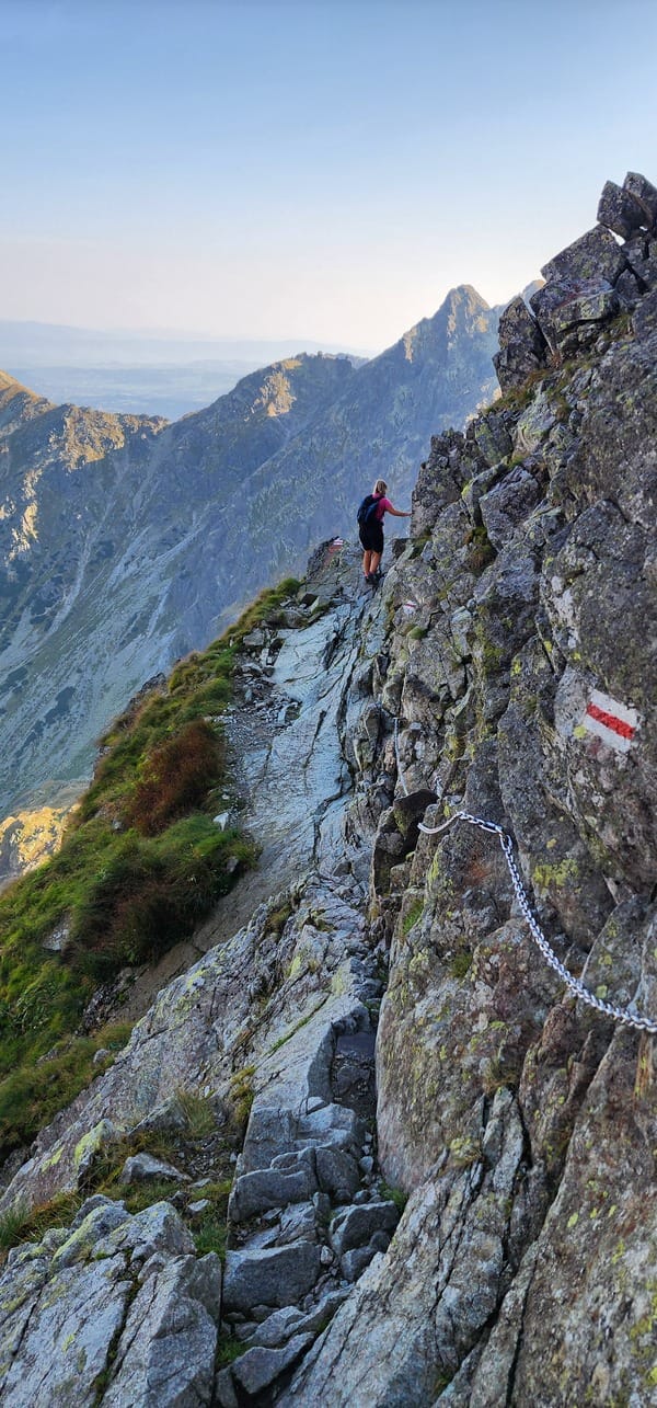
Difficulty: Orla Perć is considered the most challenging marked trail in the Polish Tatras. The trail demands significant physical fitness and experience in high-altitude hiking. Many sections are secured with chains, ladders, and metal rungs, especially around Kozi Wierch and Granaty, requiring strength, endurance, and confidence on exposed, rocky terrain. This hike is not suitable for beginners or those afraid of heights, as it involves navigating narrow ridges with steep drops on both sides.
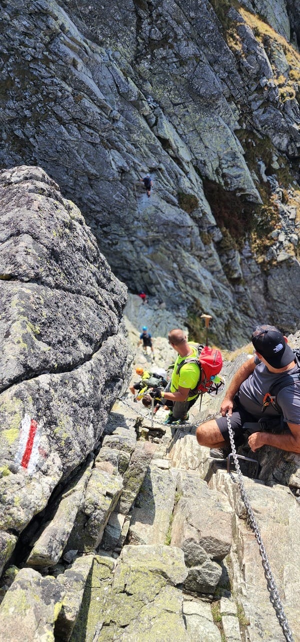
Crowds: At the start of the hike, especially near popular entry points like Kuźnice or Lysa Polana, you may encounter large crowds, particularly during the summer months or on weekends. However, the number of hikers thins out as the trail becomes more challenging and remote. For a more peaceful experience, consider starting early or hiking during weekdays.
Weather: The Tatra Mountains have a volatile microclimate, with weather conditions that can change rapidly. Sunshine can quickly give way to rain, fog, or sudden storms, making the trail slippery and dangerous. It’s essential to check the weather forecast and be prepared for sudden shifts in conditions. Thunderstorms are a serious hazard on exposed ridges like those on Orla Perć.
Trail Conditions: The path is predominantly rocky and steep, requiring careful navigation and a good sense of balance. While the trail may be clear in summer, snow and ice can linger in early and late season, making certain sections much more dangerous. Chains and ladders aid in the most difficult parts, but these can also become slippery in wet or icy conditions.
Essential Gear: Wear durable hiking boots with good ankle support and traction. Pack synthetic, moisture-wicking clothing, warm layers, and rain gear. A helmet and gloves are highly recommended due to the trail’s exposure and potential for rockfall. While not mandatory, via ferrata gear (harness, helmet, carabiners) can provide extra security for less confident hikers, especially in adverse weather. Carry at least 4-5 liters of water, as there are no reliable water sources on the trail. Magnesium and electrolyte supplements are essential for preventing cramps and maintaining hydration. Bring a headlamp, a fully charged phone, and energy-rich snacks to keep you fueled throughout the strenuous hike.
")
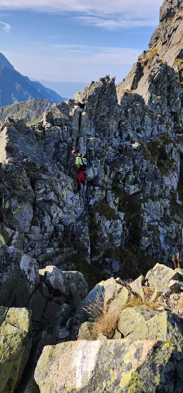
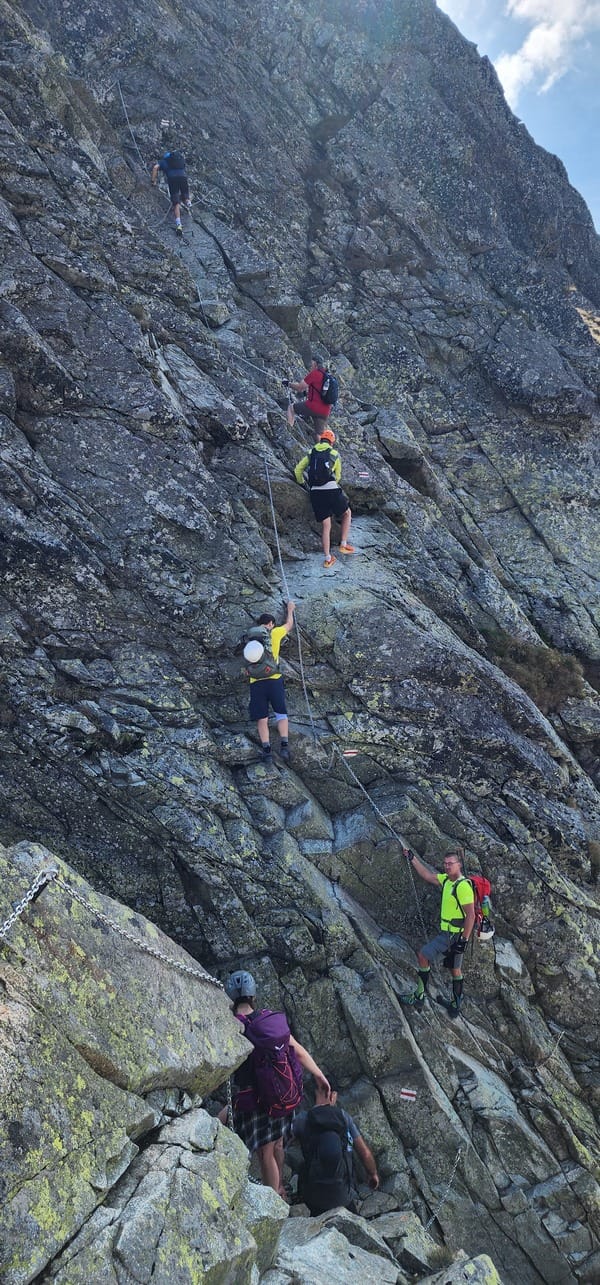
The image captures a breathtaking view of hikers descending the rugged terrain of Orla Perć. In the foreground, the trail is bordered by chains for support, ensuring safety on the steep sections
>>Orla Perć: A Hike Starting from Murowaniec Hut or Łysa Polana<<
Orla Perć starts with two main access points: Murowaniec Hut (from Zakopane) or Łysa Polana (near the Slovakian border).
1. Starting from Murowaniec Hut (Hala Gąsienicowa)
Most hikers access Orla Perć from Murowaniec Hut, which can be reached from Kuźnice in Zakopane in about 2-2.5 hours with the blue trail. From Murowaniec Hut, you hike to Zawrat Pass (2159 meters), the starting point of the Orla Perć trail. The entire hike, starting from Murowaniec, includes an elevation gain of approximately 1,422 meters and covers a distance of 14 kilometers. The highest point on the trail is Kozi Wierch (2,291 meters), and the trail from Murowaniec to the end can take 10 to 14 hours.
Once you commit from Zawrat to Kozi Wierch section, you cannot turn back, as this section is one-way.
In case of an emergency, there are multiple escape routes that enable you to descend on either side of the ridge.
Another way to reach Orla Perć from Kuźnice is to take the cable car to Kasprowy Wierch. From there, follow the red-marked trail toward Świnica Peak, continuing on to Zawrat, where Orla Perć starts.
2. Starting from Łysa Polana (Five Polish Ponds Valley)
I chose this route because it’s closer to my home in Slovakia. The additional distance and elevation gain from Łysa Polana makes this path longer and more challenging, but it adds to the adventure.
We departed Košice City at around 5:00 PM, embarking on a two-hour drive to the village of Ždiar, where we stayed overnight. Our alarm jolted us awake just before 4:00 AM, and by 4:07, we were already on our way to the parking lot at Lysá Poľana on the Slovak side. The outside temperature was a cool 14°C. Arriving at the parking lot in complete darkness, we were surprised to see a handful of cars already there. The nearby shop’s lights flickered on, and the parking attendant informed us that the fee was €13, payable in cash or by card. He also mentioned that some people were sleeping in their cars, waiting for an early start. By 4:40 AM, we left the parking lot and began our hike.
The trail starts on a paved road, and after about 15 minutes, with our headlamps lighting the way, we passed the large Palenica Białczańska parking area. If you want to park here, it’s advisable to reserve your spot online, which saves 15 minutes of walking in each direction. From this point, the red-marked trail begins.
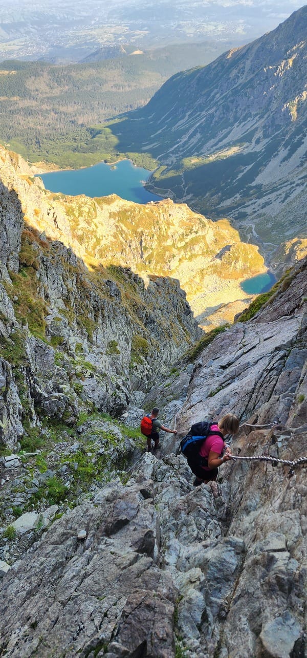
We set a brisk pace but grew a little concerned as three groups of Polish hikers passed us. Shortly after, we heard the distinctive calls of an elk echoing from the dense forest to our left. The first noteworthy stop was Mickiewicz Waterfalls, where we took a right turn to the green-marked trail that steeply climbs through the forest. After an hour of hiking, we reached the fork at Dolina Roztoki, but continued on the green trail, passing the stunning Siklawa Falls, the tallest waterfall in the Polish Tatras.
If we had taken the black-marked trail, we would have arrived at Chata PTTK, but we decided to save that route for our return journey when we could enjoy a refreshing beer. Pressing on, we passed Siklawa Falls and soon reached Wielki Staw Polski, a glacier lake and the second-largest in the Tatras.
From there, we continued through the valley, following the blue-marked trail toward Zawrat, the starting point of Orla Perć. It took us 4 hours to reach this spot, covering 12.5 km with an elevation gain of around 1,300 meters.


On the left image, you can see Wielki Staw Polski, the second-largest glacier lake in the Tatra Mountains, with its deep blue waters set against the rugged peaks. On the right image, the stunning Valley of the Five Polish Lakes stretches out, with multiple glacial lakes nestled among the mountainous terrain, offering breathtaking views of the alpine landscape.
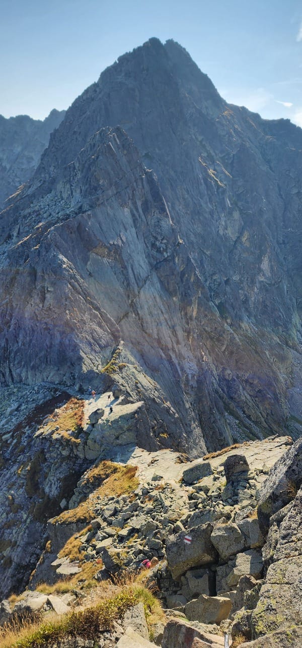
And now the real adventure begins! Orla Perć is a 4.5 km long ridge hike that takes you over around 11 peaks. The trek typically takes between 5 to 7 hours, depending on the conditions with an elevation gain of about 610 meters. From Zawrat to Kozi Wierch, the trail is one-way, and there are two escape exit routes leading back to the Valley of the Five Polish Lakes (blue-marked trail) if you get exhausted or caught in bad weather. The first is the yellow-marked trail to the fork at Tablica S. Bronikowskiego, and the second is the black-marked trail toward Dolina Pięciu Stawów Polskich, near Kozi Wierch. Beyond this point, there are three additional escape routes that descend to the other side of the valley, leading toward the Murowaniec Hut.
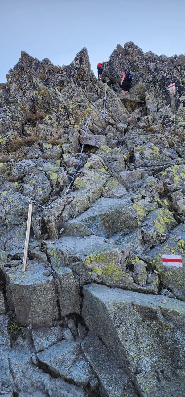
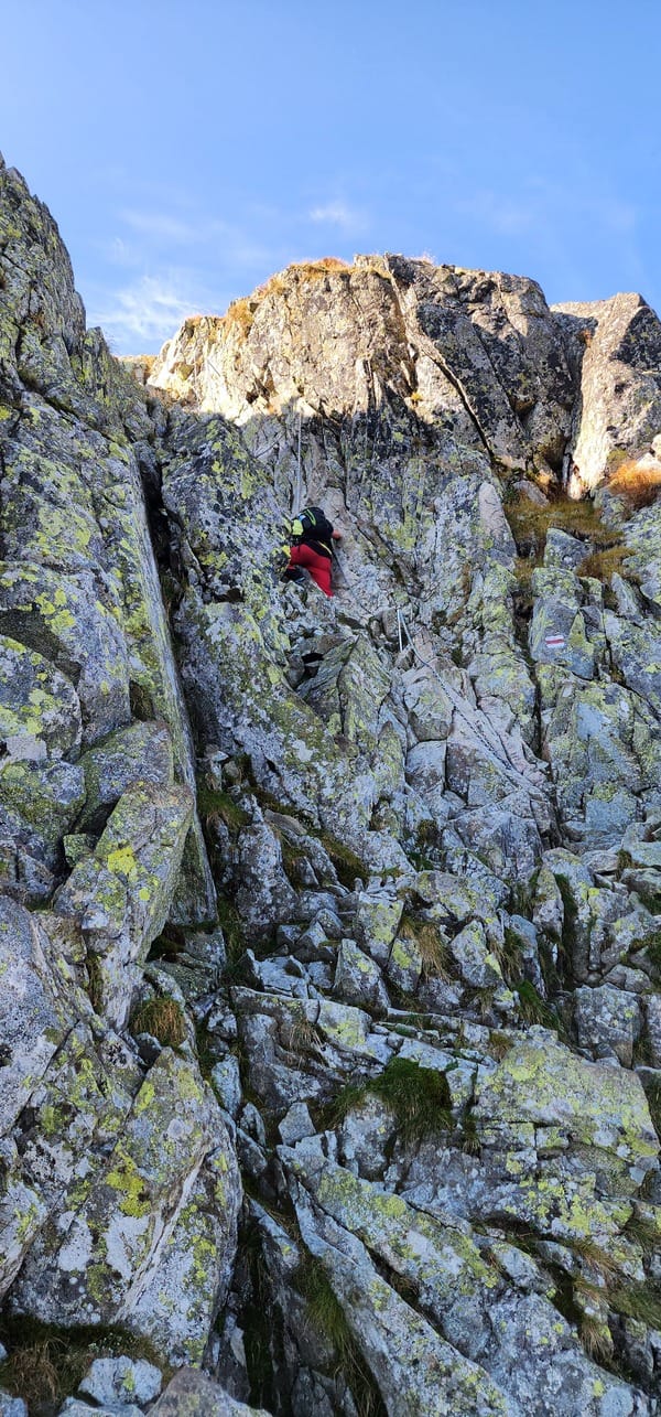
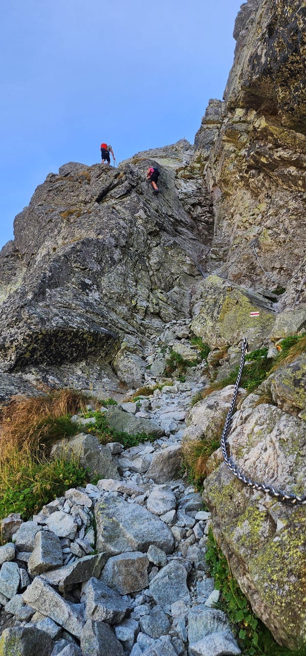
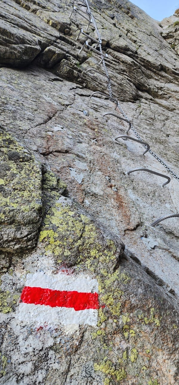
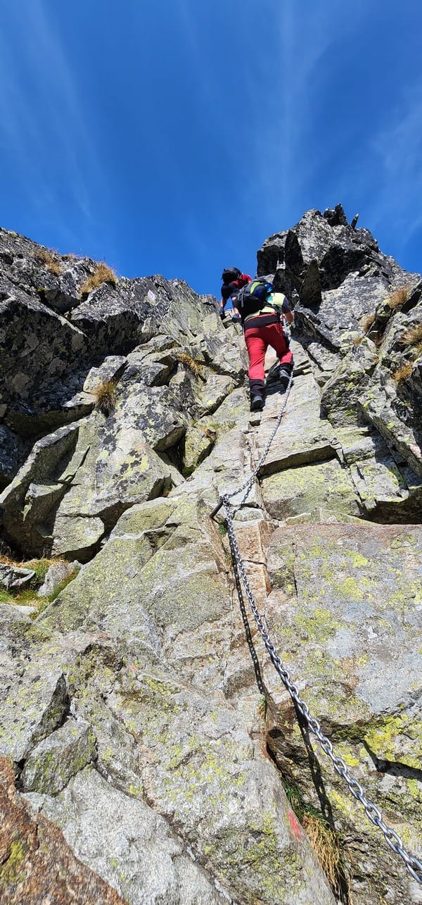
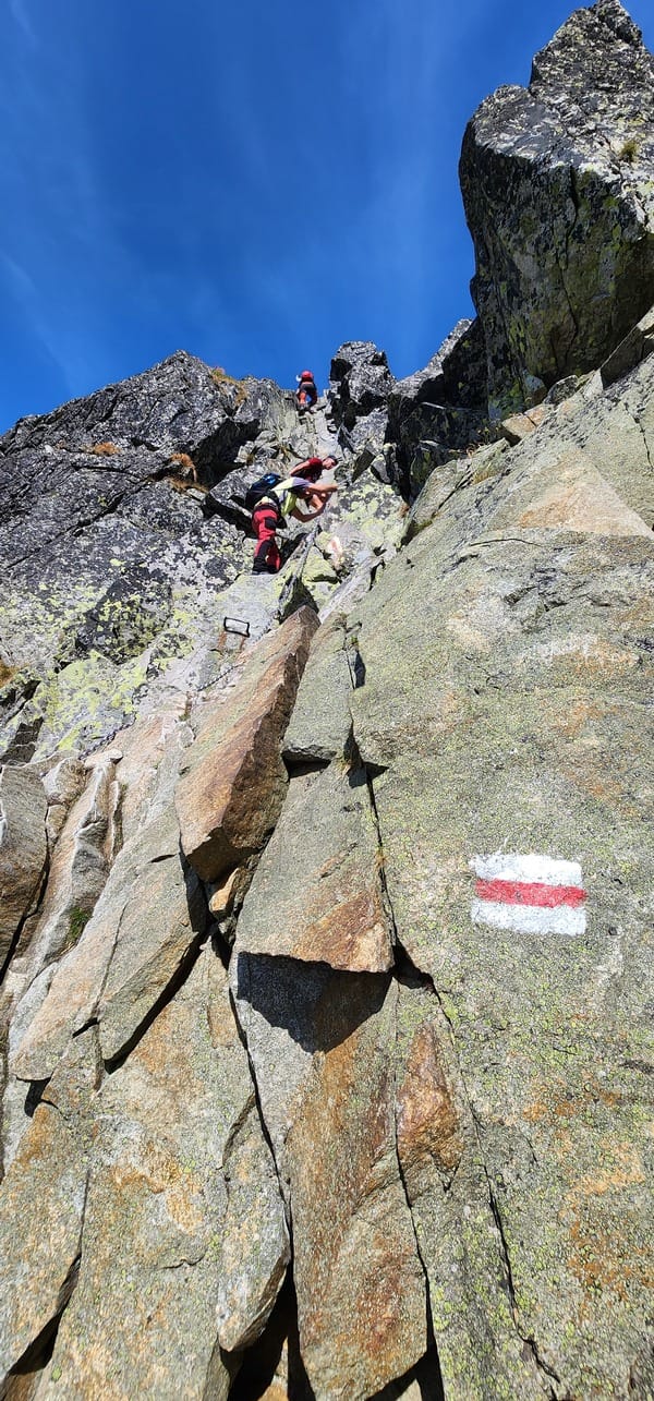
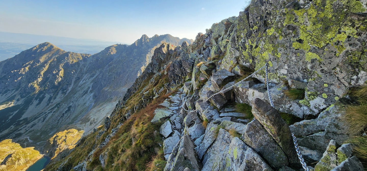
Expect a constant up-and-down traverse along sharp ridgelines at elevations near 2,100 meters. The trail has significant technical elements, such as climbing chain-assisted vertical walls and balancing along narrow ledges. The trail is well-equipped with SS316 stainless steel chains, ladders, and hardware to provide security, but this doesn’t negate the dangers involved—one misstep could result in a serious fall. The steel chains are crucial when crossing the steepest sections, but they can become bottlenecks during busy times as only one person can safely use each section of the chain at a time.
")
")
")
Around three-quarters into Orla Perć, we were hit by a sudden storm. The rain started gently, then quickly turned into a downpour, catching us unprepared on the exposed ridge of Orla Perć. Within minutes, the trail transformed from a challenging scramble into a slippery, treacherous path. Even though I wore a rain jacket, the force of the storm—combined with hail—soaked me through, making every movement feel heavier and slower. The chains, usually a lifeline for safety, became dangerously slick, forcing us to move with extreme caution.
The visibility dropped as mist and rain engulfed the peaks, creating an eerie atmosphere. What was already a demanding hike now required laser-sharp focus; each step had to be deliberate, especially with the chains that became a hazard rather than a help. The slick metal required me to balance my grip while carefully planting my feet on the increasingly unstable rocks beneath.
The rain lasted for about an hour, but it felt much longer. We were drenched, and humbled by the unpredictable forces of nature. The storm transformed Orla Perć into something even more formidable—a reminder that in the High Tatras, the weather is an equally dangerous adversary as the terrain itself. This delay stretched our hike, adding a significant physical and mental challenge, as progress slowed to a crawl on the now treacherous path.
Despite the rain subsiding, the trail remained wet and slippery for the rest of the journey. The storm reminded me that Orla Perć isn’t just a hike—it’s a test of endurance, resilience, and respect for the mountain’s ever-changing mood.
")
Reaching Krzyżne Pass (2,112 meters) was a significant achievement after hours of tackling the intense, jagged ridgeline of Orla Perć. The views from the pass were extraordinary, offering a panoramic look at the majestic Tatra landscape, with deep valleys and towering peaks as far as the eye could see. After taking a few minutes to rest and appreciate the scenery, we began our descent, relieved to leave behind the exposed ridges but aware that the hike wasn’t over yet.
The descent from Krzyżne was steep and rocky at first, but gradually it softened as the trail led us through grassy meadows. The change in terrain was a welcome relief after the technical challenges of the ridge. We carefully made our way down, following the well-worn path towards Schronisko PTTK w Dolinie Pięciu Stawów Polskich, our next stop for a break.
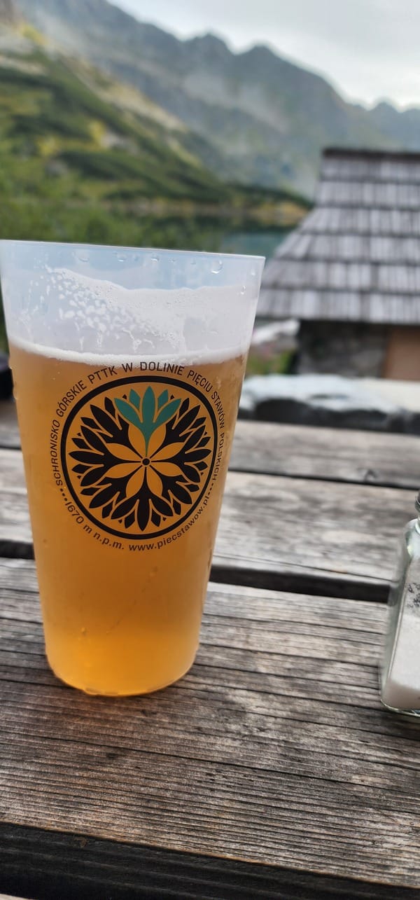
Arriving at Schronisko PTTK, nestled in the valley of the Five Lakes, was like finding an oasis after a long and demanding trek. The rustic mountain hut was a warm and welcoming refuge for weary hikers. We stopped here to rest and recharge, enjoying a well-deserved beer while taking in the views of the serene alpine lakes nearby. The atmosphere inside was lively, with fellow hikers sharing their stories of the day’s adventures. It was a perfect spot to refuel before the final leg of our hike.
Once rested, we continued our journey back towards the Łysa Polana parking lot. The final stretch of the hike, though less technical, was long and taxing, especially after the day’s intense physical demands. As we wound our way through forests and valleys, the sun began to set, casting a golden glow over the landscape. Despite our exhaustion, the beauty of the surroundings kept us going.
We finally reached the parking lot at 9:20 PM, completing an epic 16-hour and 40-minute journey, including breaks. The hike had tested us in every way—physically, mentally, and emotionally—but the sense of accomplishment was overwhelming. From the thrill of Orla Perć to the peaceful rest at Schronisko PTTK, this hike will remain etched in our memories forever.
")
Understanding the High Tatras
The High Tatras, a mountain range straddling Slovakia and Poland, offer breathtaking landscapes, diverse wildlife, and challenging hikes. To make the most of your adventure, careful planning is essential. There is no admission fee to enter Tatra National Park.
In addition to wild camping, littering, bathing in glacial lakes, building campfires, and picking flowers, Tatra National Park has several other prohibitions to protect its fragile ecosystem. Hiking off marked trails is not allowed, as it can damage the environment and disturb wildlife. Feeding animals is also prohibited, as it can harm their health and alter their natural behaviors. Motorized vehicles are banned in restricted areas to prevent damage to trails and ecosystems. Collecting natural materials, such as stones or plants, is forbidden, as is setting up permanent structures like tents or shelters. These regulations are essential for maintaining the park’s ecological integrity and ensuring that its breathtaking landscapes remain unspoiled for future generations.
The best time to visit the High Tatras for hiking is generally from late May to mid-October.
- Opening Season: Trails typically open in late May, depending on snow conditions and weather.
- Peak Season: The summer months of June to September are ideal, as the weather is usually stable and the trails are fully accessible.
- Closing Season: By mid-October, many trails begin to close due to the onset of winter weather, and snowfall can occur.
Several peaks in the High Tatras require a professional guiding service due to their technical difficulty and potential hazards. Notable examples include:
- Gerlachovský štít: The highest peak in the High Tatras, it is a challenging ascent that requires climbing skills and experience.
- Lomnický štít: While it has a cable car, the summit climb can be technically demanding and may require a guide.
- Rysy: The trail to the summit is steep and can be dangerous in certain conditions, making a guide advisable for less experienced hikers.
There are many guiding companies available, one of which is Mountain Pro Guiding. They offer a variety of guided tours and climbing experiences in the High Tatras, catering to different skill levels and preferences. Whether you’re looking to summit challenging peaks or enjoy scenic hikes, they provide professional guides to enhance your adventure.
Ensure your safety in the mountains with reliable mountain insurance.
Mountain insurance is essential when hiking or engaging in activities in the High Tatras due to the potential costs of mountain rescues, which are not covered by standard health or travel insurance. In case of accidents, individuals are responsible for paying for rescue services, such as helicopter transport or stretcher evacuation, unless covered by mountain insurance. The cost of insurance is approximately €1.50 per day.
There are two main categories of mountain insurance:
- Basic insurance: Covers hiking and movement on marked trails.
- Extreme insurance: Required for riskier activities like climbing, ski touring, or other adrenaline sports.
If you’re staying in registered accommodations within the town of High Tatras (excluding certain areas like Štrbské Pleso), you may already be insured under a collective agreement that covers search and rescue services for the duration of your stay.
For those without this collective insurance, it is advisable to purchase daily, annual, or group mountain insurance, available both online or in person at information centers in Starý Smokovec and Tatranská Lomnica.
If you’re planning to hike at altitudes over 2,000 meters or engage in multi-day treks, regular travel insurance may not suffice. Specialist mountain insurance ensures you’re covered for emergencies, equipment issues, and high-altitude risks.
You can conveniently purchase insurance from various companies online: 【install the Google Translate extension to your browser】
")
Emergency Numbers for the High Tatras
In case of an emergency in the High Tatras, please dial:
- Mountain Rescue:
- Slovakia: 18 300
- Poland: 601 100 300 (TOPR)
- General Emergencies (police, fire, ambulance):
- Slovakia and Poland: 112
For more information, please visit:
- Mountain Rescue Service Slovakia: Mountain rescue service Slovakia: https://hzs.sk/
- TOPR Mountain Rescue Poland: https://topr.pl/
- Official website of High Tatras National Park: http://www.tanap.org/english/
Remember to inform someone of your hiking plans before setting off, including your intended route and expected return time.
For the most accurate and up-to-date weather conditions in the High Tatras, you can visit the Meteo HZS website. This site provides real-time data, including temperature, wind speed, and other critical weather parameters for various locations in the High Tatras. It’s an excellent resource for planning your activities in the mountains, ensuring you have the latest weather information at your fingertips.
Reaching the High Tatras
By Air
Poprad-Tatry Airport (TAT): This is the closest airport to the High Tatras, just 12.5 km from the heart of the region. It’s an ideal option if you’re short on time or prefer a hassle-free journey. The airport offers flights from several European cities, including London (Luton), Warsaw, and Riga, mostly operated by Wizz Air. Upon arrival, you can easily reach popular resorts like Stary Smokovec or Štrbské Pleso via taxi, bus, or the Tatra Electric Railway (TEŽ), which connects directly from Poprad.
Bratislava Airport (BTS): Located further away, Bratislava Airport is a larger hub with more international flight options. However, getting to the High Tatras from here requires additional travel time. You can either rent a car and drive for about 3.5 hours or take a direct train to Poprad, which takes approximately 4 hours.
Krakow Airport (KRK): If you’re coming from Poland, Krakow Airport is a viable option. From Krakow, you can reach the High Tatras by renting a car, taking a bus, or traveling by train, although the journey is longer (around 3-4 hours) compared to starting from Poprad.
By Train
Poprad-Tatry Station: Poprad serves as the main gateway to the High Tatras. The station is well-connected to major cities like Bratislava, Košice, and even Prague in the Czech Republic. Trains are a comfortable and scenic option, especially if you’re traveling from within Slovakia or nearby countries. The Tatra Electric Railway (TEŽ) is a must-try; this scenic narrow-gauge train takes you from Poprad to key destinations like Stary Smokovec, Štrbské Pleso, and Tatranská Lomnica. The trains are modern, and tickets are affordable, typically costing around 2-3 EUR for a return journey depending on the distance.
By Bus
FlixBus and Local Buses: For budget-conscious travelers, buses provide an economical way to reach the High Tatras. FlixBus operates routes from various European cities to Poprad, making it an accessible option if you’re coming from places like Vienna, Budapest, or Prague. Once in Poprad, you can switch to local buses operated by Slovenská Autobusová Doprava (SAD Poprad), which run frequently between towns like Stary Smokovec, Tatranská Lomnica, and Štrbské Pleso. Look for the “TATRA EXPRESS” marking on buses for the quickest routes within the region.
By Car
Driving: Renting a car gives you the freedom to explore the High Tatras at your own pace. The roads leading to the mountains are well-maintained and offer stunning views of the Slovakian countryside. However, parking near popular trailheads and resorts can be limited, especially on weekends, so it’s best to arrive early. Parking typically costs around 10 euros, payable either in cash to an attendant or by card at a kiosk machine. Having a car is especially convenient if you plan to visit multiple towns or explore more remote hiking trails.
In general, and especially in Slovakia, it’s important to pay close attention to traffic rules and monitor your speed, as there is a significant police presence on the roads. Speed cameras are common, particularly in resort areas, where police are often stationed at either end of the village or town. Be mindful of speed limits, even in less populated areas, as radar traps can be set up unexpectedly. Also, keep an eye out for pedestrian crossings in smaller towns, as traffic rules are strictly enforced.
Unlike some other European countries, Slovakia has a strict zero-tolerance policy for alcohol when driving. Even a small amount of alcohol in your system, such as from a single beer, is prohibited. It’s important to be fully aware of this regulation to avoid serious penalties.
")
Here are some essential apps to consider for navigation and hiking in the High Tatras:
Gaia GPS or AllTrails: Both apps are highly regarded for outdoor activities, offering detailed topographic maps, trail information, and GPS tracking features. They are particularly useful for more serious hikers who need reliable data on elevation and trail conditions.
Google Maps: Widely used for general navigation, it offers detailed road maps, public transport routes, and some hiking trails.
Mapy.cz: Particularly popular in Central Europe, this app provides excellent offline maps with detailed hiking and cycling routes, including terrain features and points of interest.
Maps.me: Known for its offline capabilities, Maps.me offers a comprehensive set of trails and hiking paths, making it useful in areas with limited connectivity.
Where to Stay
Accommodation in Zakopane, Poland and Zdiar, Slovakia:
Zdiar, Slovakia: Primarily offers guesthouses and apartments, providing a more peaceful and traditional experience.
Zakopane, Poland: Offers a wider range of options, including guesthouses, hotels, and mountain huts. It has a more vibrant atmosphere and more amenities.
Popular booking platforms: Booking.com, Agoda, Airbnb, Zlavomat.sk
")
")
")
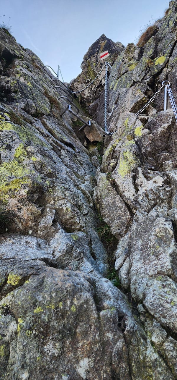
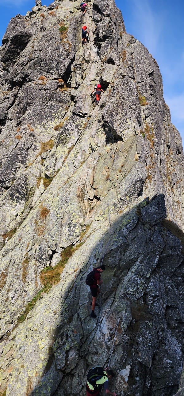
The ladder section of Orla Perć, specifically Kozia Przełęcz (Goat Pass), is a particularly challenging and iconic part of the trail. It features a series of exposed metal ladders that are bolted to the sheer rock face.
")
")
")
")
")
")